Protecting people and planet
Protecting people and planet
Protecting people and planet
Protecting people and planet
Protecting people and planet
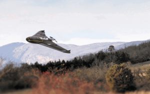
Surveying with a UAV

Lucion Group
27th June, 2016
In recent months we have looked at the Trimble TX8 laser scanner to complement our existing FARO scanner, and have also looked at various UAV systems to evaluate their use and performance.
While UAV (unmanned aerial vehicles) aren’t new technology, it’s only been within the past few years that they have become affordable enough to be popular for commercial and civilian use. Having heard good things about the benefits that they provide, we decided to look into how we could use them to improve the surveying experience for clients.
Last year, we trialled the Trimble UX5 to survey a quarry in Cumbria and were very impressed with the results. The quality of the survey data was good and our client was impressed with the ortho rectified aerial image that was produced.
In May of this year two of our surveyors, Peter Nelson and Adam Simms, assisted in the drone surveying of another quarry using a Trimble eBee UAV.
 The UAV took around 1 hour to fly the site, which is far quicker than conventional methods. Data processing takes longer, but this can be done overnight to save office time. The quality of the images is so good that most features surveyed by conventional means can be mapped using the aerial data. Other benefits to using a UAV means improved health and safety, minimal disruption to the site, environmentally friendly and better turn around time for producing the survey.
As well as quarry surveys, the technology can be used for stockpile volumetric surveys, measured building surveys where access to roofs is problematical, and large topographic surveys.
The UAV took around 1 hour to fly the site, which is far quicker than conventional methods. Data processing takes longer, but this can be done overnight to save office time. The quality of the images is so good that most features surveyed by conventional means can be mapped using the aerial data. Other benefits to using a UAV means improved health and safety, minimal disruption to the site, environmentally friendly and better turn around time for producing the survey.
As well as quarry surveys, the technology can be used for stockpile volumetric surveys, measured building surveys where access to roofs is problematical, and large topographic surveys.
Eric Hinds, director of Landform Survey on conducting UAV surveys:
“Our surveyors have been impressed with the capabilities of the UAV systems we have trialled, and it certainly looks like this technology is something that Landform Surveys could utilise in the future”Based on the success we have had with UAV surveys so far, we will continue to evaluate UAV systems in the future.
Register for IMPACT Bulletin
Don’t miss a beat - get the latest insights and updates from Lucion straight to your inbox.

Verified. Accredited. Certified. Trusted.


Manage Cookie Consent
To provide the best experiences, we use technologies like cookies to store and/or access device information. Consenting to these technologies will allow us to process data such as browsing behaviour or unique IDs on this site. Not consenting or withdrawing consent, may adversely affect certain features and functions.
Functional Always active
The technical storage or access is strictly necessary for the legitimate purpose of enabling the use of a specific service explicitly requested by the subscriber or user, or for the sole purpose of carrying out the transmission of a communication over an electronic communications network.
Preferences
The technical storage or access is necessary for the legitimate purpose of storing preferences that are not requested by the subscriber or user.
Statistics
The technical storage or access that is used exclusively for statistical purposes.
The technical storage or access that is used exclusively for anonymous statistical purposes. Without a subpoena, voluntary compliance on the part of your Internet Service Provider, or additional records from a third party, information stored or retrieved for this purpose alone cannot usually be used to identify you.
Marketing
The technical storage or access is required to create user profiles to send advertising, or to track the user on a website or across several websites for similar marketing purposes.